Back to results Land for Sale in Kanie Town, Aichi Prefecture

Verified Listing

This property was checked recently and confirmed to still be available. Tap for details.

Verified Listing

This property has been verified in the last month. Our system regularly checks listings to ensure they are still available.

Last verified: April 25, 2026

Know someone who would love this? Gift them a subscription

¥23,980,000

Ama District, Kanie Town, Nishiki 2-chome, Aichi Prefecture

愛知県海部郡蟹江町錦2丁目

Listing No Longer Available

Sign in to save properties

Sold Land Gas Heating/Cooking Septic System

Unlock the full description with a free trial

Includes AI translation, hazard data, cost estimates & nearby amenities

3 days free · cancel anytime

Start Free Trial

A Residential Plot in Kanie Town

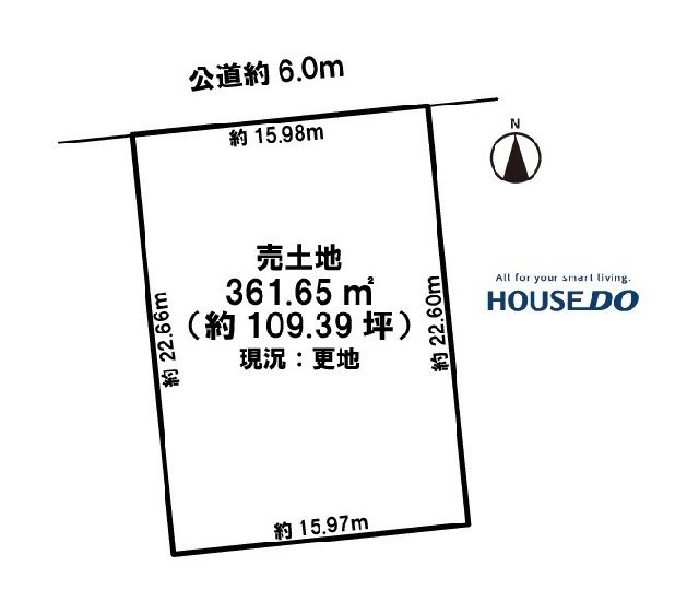
This 361.65 square meter plot of land is available for purchase in Kanie Town, Aichi Prefecture. Situated in a flat, residential area zoned for Category 2 Exclusive Residential use, the land offers a building-to-land ratio of 60% and a floor area ratio of 200%. The property is fully serviced with electricity, propane gas, and a septic tank, with a planned connection to the public sewer system expected in the 2028 fiscal year.

The town of Kanie is located within Aichi's Ama District, an area historically known for its intricate network of rivers and canals that were vital for transportation and agriculture. The property is approximately a 23-minute walk from Kanie Station, providing access to both JR and Kintetsu railway lines. The closest major landmark is Nagoya Castle, a historic Japanese fortress located roughly 15 kilometers to the east, which serves as a prominent symbol of the region.

This description was AI-generated from the original Japanese listing and may contain inaccuracies. Please verify details with the source listing.

Summary

Land size: 362 / 3,893sqft

Short-Term Rental (Minpaku)

Transport

Nearby Konbini

Seven Eleven Seven Eleven — 15 min walk

Internet Connectivity

Natural Hazard Assessment

Flood Risk Low Risk
Landslide Risk Moderate
Tsunami Risk Low Risk
Earthquake Hazard Moderate

Unlock hazard data with a free trial

Flood, landslide, tsunami & earthquake risk for this property

3 days free · cancel anytime

Start Free Trial

Map & Street View

Map loading...

Location Accuracy Notice: Although we try to make the map accurate with coordinates or address details provided, the location data is provided by the agent. This map data should be used as reference for the surrounding area foremost.

Location Type Beds Price Land House View

* Sold properties shown for price comparison only. Prices reflect historical sale data.

Location Type Beds Rent/Month Land House View

* Rental prices shown are monthly rates. Contact property owner for current availability.

Dev Bot
Task #
Draw to highlight areas, then tap Done to attach